
This excerpt from a draft of my upcoming book finds surveyor Thomas Speight leading an Ontario government party to Abitibi in June 1900. Speight’s party is one of ten sent out by the province to take stock of New Ontario between the transcontinental Canadian Pacific Railway in the south and the Albany and English Rivers in the north. The party left Toronto on 18 June, travelled by train and steamship to Lake Temiskaming, and have been portaging and paddling the fur trade route to Lake Abitibi for the last six days.
On Monday the group had a “delightful trip” down Snake Creek, Island Lake, and the Island River.1 Philip Graham-Bell noted squared white pines left here by lumbermen the previous winter, waiting to be hauled over the height of land portage and driven down the Quinze to the Ottawa River and beyond. The group stayed put the next day owing to heavy rain. On day seven they paddled through a light drizzle to Upper Lake and the Upper River.2 Manly Baker described Upper Lake as beautiful, “studded with islands, many bays.” Even at this date, four days after the summer solstice, the group found ice on a hillside.3
The following day dawned rainy. Most of the group stayed put on the Upper River. Speight proceeded downriver to Fort Abitibi, the HBC post on Lake Abitibi, to fetch a larger canoe. The next day, the group met Speight with the new canoe downstream at Dancing Rapids. Early the next morning, ten days after leaving Toronto, the party reached Fort Abitibi, where they were “most kindly received by the officers of the Company.”4 Speight, impatient after a week of difficult travel, recorded:
A whole week had been consumed in transporting our five tons of supplies, camp equipage, etc., over the ninety miles lying between Klock’s Depot and Abitibi Post through the Province of Quebec, with a force of twenty-five men, all told.
By the late nineteenth century, European fur traders had been active on Lake Abitibi for over two centuries. Their first presence on the lake was in 1686, when Pierre Chevalier de Troyes led a military expedition from Montreal to seize HBC posts on James Bay. de Troyes built a small fort on Lake Abitibi, which supported independent French traders until the British conquest of New France. From then until 1821, the Northwest Company operated Fort Abitibi. With the merger of the two rival fur trading companies in that year, the fort was now under the control of the HBC. Like Fort Temiskaming, Fort Abitibi’s importance in the fur trade declined in the last decades of the nineteenth century. Despite this, the site remained vibrant, at least in the summer months. The Abitibi Algonquin gathered at the fort after ice out in the spring. Ostensibly they gathered to trade furs and participate in Roman Catholic missions. The same Oblates who ministered to the Algonquin at Temiskaming held annual missions at Abitibi beginning in the 1840s. Abitibi Algonquin socio-economic organization revolved around family hunting territories. Between freeze up and ice out, roughly mid-October to mid-May, they hunted and trapped in small groups of one or two families on individually-held family lands. Come spring, these families gathered on Lake Abitibi for weeks or months of community togetherness, celebration, marriages, politicking, and religious practice.5
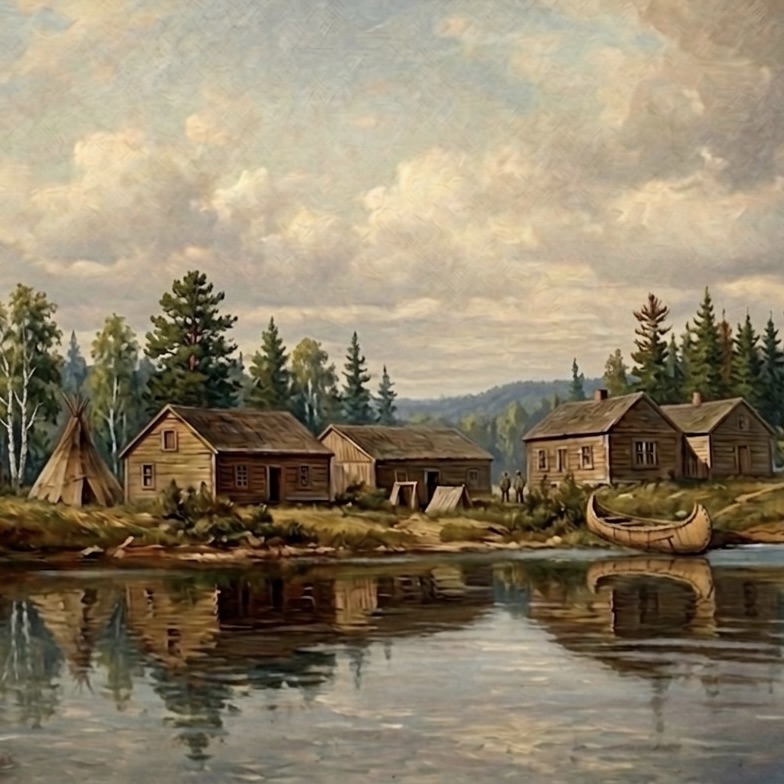
How Fort Abitibi may have appeared to Speight, based on a 1910 photo. Image created by Robert Olajos using AI.
When he arrived at Fort Abitibi, Speight found hundreds of tents occupied by Abitibi Algonquin. Tents lined the lakeshore and even spilled over to nearby islands. Many of the inhabitants were stricken with influenza, nearly all coughing badly. Two had died. Two priests were busy administering last rites to others.6 Of the post, Speight wrote, it is “situated on a picturesque point which extends into the lake from the eastern end.”7 He makes no mention of the tragedy gripping the community.
With this desperate scene unfolding around him, Speight got on with his work.8 He purchased extra clothing, stored the bulk of his dry foodstuffs in the post’s warehouse, and rented a canoe. He also hired three Abitibi Algonquin as guides and packers, on whom he would rely for their detailed knowledge of the land and routes ahead.9 While Speight mentions the men, nowhere does he mention the degree to which he would depend on them. One of these men, identified only as Michel, was married the day before. Years later, the veteran surveyor would recall that Michel started the trip “in rare good humour.”10
Speight’s party, now totalling twenty-six men, paddled west and camped on a large island; they were at the post but a few hours. Rain and heavy winds lashed the island for the next two days. “Disagreeable day, raining, water rough. Stayed on island,” wrote the geologist Baker.11 With a sparse writing style that reveals his scientific and academic background, it is hard to read into Baker’s emotions or motivations.
By July 1, Dominion Day, the rain stopped but the wind continued to howl. Speight woke his party with three cheers for Canada. Full of colonial confidence, he named the island Dominion Island, a name it holds to this day. There is no record of what the island was called by the Abitibi Algonquin, who had been living on this land for millennia.
1 Island Lake is now Lac Dasserat and Island River is now Rivière Kanasuta. Speight, “Exploration Survey Party No. 1,” 2.
2 Upper Lake and River are now Lac Duparquet and Rivière Duparquet.
3 P. F. Graham-Bell, “Report of P. F. Graham-Bell, Timber Estimator on Exploration Party No. 1,” Exploration parties of northern Ontario records—Party No. 1, Archives of Ontario (AO), RG 1-411-1 (hereafter Party No. 1 files), June 27, 1900.
4 Graham-Bell, Report of the Survey and Exploration of Northern Ontario, 1900, 8.
5 Leila Inksetter, translated by Bruce Inksetter, Cultural Change Among the Algonquin in the Nineteenth Century (Montreal: McGill-Queen’s University Press, 2024), 365.
6 Graham-Bell, “Report of P. F. Graham-Bell, Timber Estimator on Exploration Party No. 1,” Party No. 1 files, June 28, 1900; R. W. Coulthard, “Diary of exploration no. of Abitibi Lakes—R. W. Coulthard, Geologist, Party 1,” Party No. 1 files, June 28, 1900.
7 T. B. Speight, “Exploration Survey Party No. 1,” Report of the Survey and Exploration of Northern Ontario, 1900 (Toronto: L. K. Cameron, 1901), 2.
8 R. W. Coulthard, “Geologist’s Report on Exploration. Survey Party No. 1,” Report of the Survey and Exploration of Northern Ontario, 1900 (Toronto: L. K. Cameron, 1901), 38.
9 Speight, Report of the Survey and Exploration of Northern Ontario, 1900, 2.
10 Don W. Thomson, “Thomas Bailey Speight,” The Ontario Land Surveyor, (Thornhill, ON: Krcmar Surveyors Ltd., 2026), Winter 1979, https://krcmar.ca/resource-articles/1979_Winter_Thomas%20Bailey%20Speight_0.pdf, 19.
11 M. B. Baker, “Diary of M. B. Baker, Geologist,” Party No. 1 files, June 29, 1900.
